
For years, getting around Los Angeles meant renting a car or staying close to your hotel. Metro now makes car-free travel more practical than before. A growing rail network, affordable fare caps, rail access to LAX, and a city-wide bike share program give most visitors a real alternative to renting a car.
This guide covers how to get around in Los Angeles without a car. We walk through Metro rail and bus, the new LAX/Metro Transit Center, walkable neighborhoods, bike share, rideshare, and guided tours. For each option, you’ll learn what it costs, what it gets you, and when to use it.
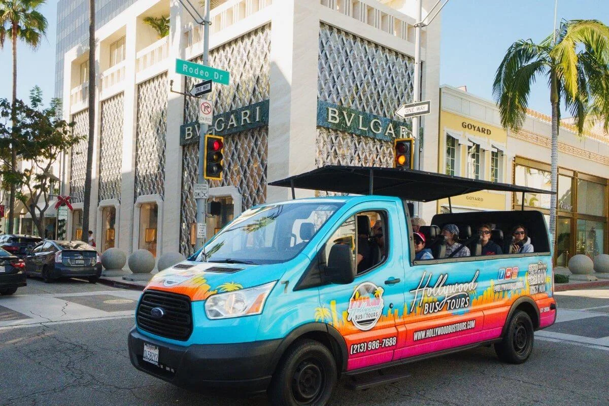
If you’d rather leave the driving to local experts, our tours cover celebrity homes, the Hollywood Sign, Rodeo Drive, and the Santa Monica Pier with a driver-guide who knows the city inside and out.
Over 18,000 five-star reviews have called our tours a must-do Hollywood experience. Reserve your Hollywood Bus Tours experience here.
What You’ll Find in This Guide
- Public Transportation in Los Angeles Overview
- Metro Rail for Getting Around Los Angeles Without a Car
- Riding the Metro Bus and Other Bus Lines
- How to Get To and From LAX Without a Car
- The Most Walkable Neighborhoods to Explore Los Angeles
- Bikes, Scooters, and the Beach Path
- Rideshare, Taxis, and Robotaxis
- When You Might Still Want a Rental Car
- Guided Tours as a Way of Getting Around the City
- Practical Tips for Getting Around LA
- Frequently Asked Questions About Getting Around LA
Public Transportation in Los Angeles, A Quick Guide
Los Angeles Metro operates two main types of public transportation: rail and bus. The rail network runs six lines across the region, two of which are underground subways and four of which are light rail. The bus network covers more than 165 routes, reaching neighborhoods and destinations that the rail lines do not serve.
All Metro services use the same TAP card, a reloadable pass that works across rail, bus, and most municipal transit systems in the area. Several other local operators also serve specific parts of the city, including the Big Blue Bus in Santa Monica, LADOT DASH in Downtown and Hollywood, and the free PickUp trolley in West Hollywood.
The sections below cover each option in more detail, starting with the rail lines that connect the city’s biggest destinations.
Metro Rail for Getting Around Los Angeles Without a Car
Metro Rail connects most of the destinations visitors want to reach, running six lines from Downtown LA to the coast, the airport, and the San Fernando Valley. The system runs daily from roughly 4 a.m. to midnight, with trains every 10 minutes on most lines throughout the day.
Metro Rail Subway and Light Rail Lines for Visitors
Two lines run as underground subways. The other four run as light rail at street level or on elevated tracks.
B Line (formerly the Red Line)
The B Line subway runs from Union Station through Koreatown to Hollywood, then north to Universal City and North Hollywood. Hollywood/Highland station sits directly on Hollywood Boulevard, steps from the Walk of Fame. For visitors based in Hollywood, this is the line they will use most.
D Line (formerly the Purple Line)
The D Line subway runs from Union Station west along the Wilshire corridor. The line now serves Wilshire/La Brea, Wilshire/Fairfax, and Wilshire/La Cienega, bringing subway access to the Miracle Mile, the Fairfax District, and the edge of Beverly Hills. The B and D Lines share tracks between Union Station and Koreatown.
E Line (formerly the Expo Line)
The E Line light rail runs from Santa Monica through Culver City to Downtown LA and continues east toward East LA. It is the most direct rail route between the coast and the city center.
A Line
The A Line light rail connects Long Beach to Azusa, passing through Downtown LA. Most visitors use this line for trips to Long Beach or Pasadena.
C and K Lines
Both lines serve the LAX/Metro Transit Center. The C Line runs from Norwalk and the K Line runs from Expo/Crenshaw to Redondo Beach, with a stop at the LAX/Metro Transit Center along the route. Either line connects you to the free shuttle that runs to the airport terminals.
Metro Fares and the TAP Card
A single Metro ride costs $1.75 and includes two hours of free transfers. Fare capping means you will never pay more than $5 in a single day or $18 in a seven-day period, as long as you pay with a TAP card.
Getting a TAP card
Pick up a physical card at any Metro rail station vending machine for $2, or load a virtual TAP card through the TAP LA app onto Apple Wallet or Google Wallet, which skips the $2 card fee. Standard contactless credit cards do not work at the gates.
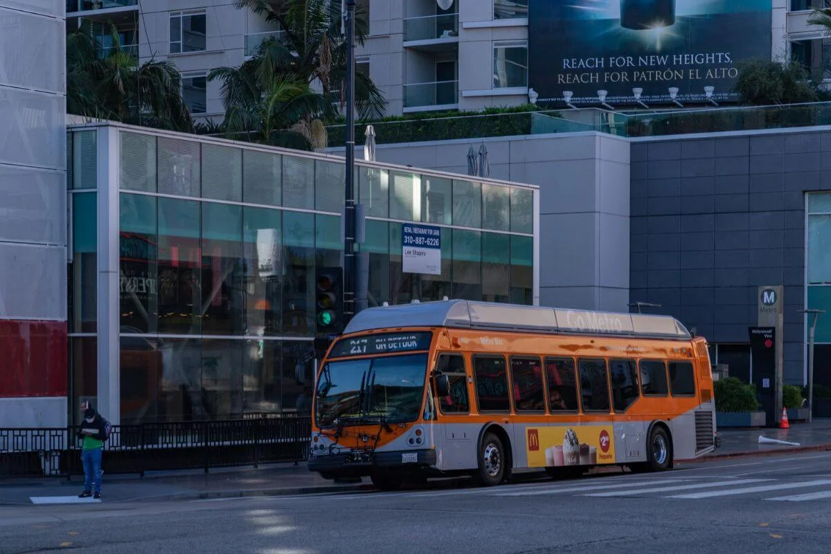
Riding the Metro Bus and Other Bus Lines
Metro’s bus network runs alongside the rail system, reaching neighborhoods the rail lines do not serve. The same TAP card and $1.75 fare apply on Metro buses, with two hours of free transfers included.
Metro Bus and Metro Rapid
Metro Local buses stop frequently along major corridors across the region. Metro Rapid buses run limited-stop service on key routes, including Wilshire Boulevard, for faster travel between major destinations. Both use the same TAP card and fare structure.
Big Blue Bus in Santa Monica
The Big Blue Bus operates Santa Monica’s local bus system, connecting the beach, the Third Street Promenade, and UCLA. TAP cards work on Big Blue Bus routes, though transfer rules and fare policies vary between Metro and Big Blue Bus services.
LADOT DASH and Commuter Express
LADOT DASH buses run short routes in Downtown LA, Hollywood, and several other neighborhoods at low per-ride fares. The DASH Observatory route connects to Griffith Observatory and is worth checking at ladottransit.com for current schedules before your visit. LADOT’s Commuter Express connects the San Fernando Valley and South Bay to Downtown LA during morning and afternoon rush hours.
The PickUp and Metro Micro
West Hollywood runs a free trolley called The PickUp along Santa Monica Boulevard on weekend evenings. Metro Micro is an on-demand shuttle bookable through the Metro Micro app, covering select zones across the city. Check metro.net for current fares and zone coverage before you go.

How to Get To and From LAX Without a Car
Getting to and from Los Angeles International Airport without a car is more practical than it used to be. LA Metro’s rail network now provides rail access to LAX via the LAX/Metro Transit Center, and dedicated bus services connect the airport to key destinations across the city.
The Free LAX Shuttle and the K Line
A free shuttle bus runs every 10 minutes between all LAX terminals, including Tom Bradley International Terminal, and the LAX/Metro Transit Center. Look for the pink shuttle signs at the arrivals level of your terminal. From the transit center, take the K Line or C Line to connect to the broader Metro rail network.
Travel times vary by destination. From the transit center, the K Line connects to Expo/Crenshaw, where you can transfer to the E Line toward Santa Monica or continue toward Downtown LA.
The free shuttle bus is a temporary service. A direct people mover connection between the transit center and the terminals is planned as a permanent replacement. Check metro.net for the latest status before your trip.
The FlyAway Bus
The LAX FlyAway bus provides non-stop service between the airport and two key transit hubs: Union Station in Downtown LA and Van Nuys in the San Fernando Valley. It is a straightforward option for transportation between LAX and the city center without navigating traffic yourself. Check lawa.org for current schedules and fares before your trip.
Rideshare from the Airport
Uber and Lyft pickups at LAX operate from LAX-it, a dedicated rideshare lot separate from the terminal curbside. Follow the LAX-it signs from the arrivals level of your terminal. Fares vary by time of day and traffic conditions, and surge pricing is common during peak hours and busy travel periods.
The Most Walkable Neighborhoods to Explore Los Angeles
Not every part of Los Angeles requires a car. While the city is spread out, several neighborhoods are compact enough to explore on foot once you arrive, and most connect to Metro rail or bus from central starting points like Hollywood and Downtown LA.
Hollywood
The Walk of Fame, TCL Chinese Theatre, and Dolby Theatre all sit along Hollywood Boulevard within easy walking distance of each other, directly served by Hollywood/Highland station on the B Line.
Our self-guided walking tour of Hollywood Boulevard covers the full stretch if you want a structured route. If you’re driving in for the day, our Hollywood parking guide covers your closest options.

Downtown Los Angeles
Downtown LA is served by multiple Metro rail lines including the A, B, D, and E Lines, plus DASH bus routes that cover short trips around the neighborhood. Grand Central Market, The Broad, and Walt Disney Concert Hall are all walkable from central Downtown stations.
Santa Monica
Santa Monica is the western terminus of the E Line, making it one of the easiest beach destinations to reach by rail. The Third Street Promenade, the Santa Monica Pier, and Ocean Avenue are all within walking distance of the Metro station.
West Hollywood
West Hollywood is one of the most walkable cities in California, with the Sunset Strip, the Design District, and Santa Monica Boulevard all easy to explore on foot. The free PickUp trolley runs along Santa Monica Boulevard on weekend evenings for short hops around town.
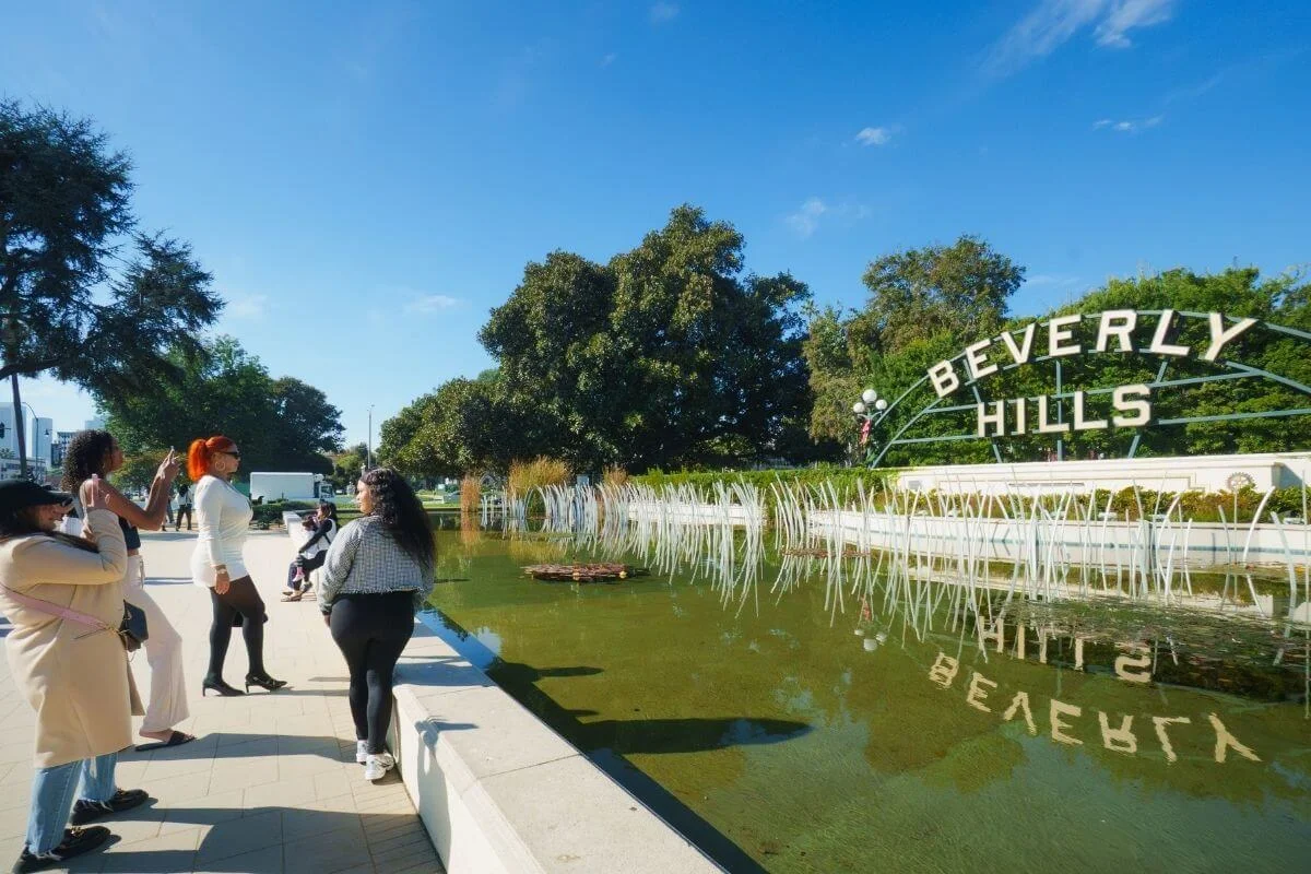
Beverly Hills
The streets south of Santa Monica Boulevard around Rodeo Drive make Beverly Hills one of the more walkable upscale neighborhoods in L.A. The D Line now serves Wilshire/La Cienega at the edge of the neighborhood.
Universal City and North Hollywood
The B Line stops at Universal City station, putting Universal Studios Hollywood and the NoHo Arts District within easy reach by rail. Hollywood or Universal City are both straightforward rail trips from central LA on the B Line.
Hollywood’s biggest landmarks are spread across the city, and most visitors want to hit every one. Our tours are expertly designed to make that easy: efficient routes, the stories behind every landmark, and a driver-guide handling the logistics so you can sit back and enjoy the ride.
Book your Hollywood Bus Tour today.

Bikes, Scooters, and the Beach Path
For shorter trips around town, bikes and scooters offer a flexible option for getting around without a car or rideshare.
Metro Bike Share
Metro Bike Share runs more than 200 stations across Downtown LA, Central LA, Hollywood, North Hollywood, and the Westside. The system uses both classic and electric bikes, available 24 hours a day. Pricing typically starts at $1.75 for the first 30 minutes, with day and monthly pass options. Check bikeshare.metro.net for current pricing and station locations.
The Beach Path
The Marvin Braude Bike Trail runs about 22 paved miles along the coast, from the Pacific Palisades through Santa Monica and Venice down toward Torrance. It is one of the easiest ways to see the LA coast on two wheels, with rental shops along the way in Santa Monica and Venice if you do not bring your own.
E-scooters
Electric scooters from various rental apps are available in Hollywood, Santa Monica, Downtown LA, and several other neighborhoods. They work well for short last-mile trips between transit stops or hotels and nearby attractions. Check local rules on where you can ride and park before using them.
Rideshare, Taxis, and Robotaxis
When transit and walking do not get you where you need to go, rideshare and taxis fill the gap. They are also the simplest option for late-night trips or destinations off the rail map.
Uber and Lyft
Uber and Lyft cover the metro area with full service. Like Uber or Lyft anywhere else, fares vary by time of day and traffic, with surge pricing during rush hour, major events, and bad weather. They are a reliable option for trips into the Hollywood Hills, Malibu, or anywhere outside the Metro footprint.
Waymo Robotaxis
Waymo operates fully autonomous ride-hailing in Los Angeles through the Waymo One app. Coverage and availability change over time, so check the Waymo app for the current service area and freeway availability before counting on them for your trip.
Traditional Taxis
For traditional metered taxis, the Curb app lets you book a ride or hail one through your phone. They cost slightly more than rideshare on average but operate without surge pricing
When You Might Still Want a Rental Car
Most visitors do not need a car for a trip focused on Hollywood, Beverly Hills, Santa Monica, and Downtown LA. There are a few situations where a car rental still makes sense.
Day Trips Outside the City
If you plan to visit Malibu, Joshua Tree, Big Bear, or wineries in Santa Barbara, a car rental gives you flexibility transit cannot match.
Staying in Less-Connected Areas
Some neighborhoods in the South Bay, the deep San Fernando Valley, or further outlying areas have limited transit access. If your hotel is in one of these areas, you may need a car for daily trips.
Heavy Itineraries Across Multiple Regions
If your trip involves multiple counties or you plan to cross long distances daily, a rental car can save time even with parking costs added in.
Guided Tours as a Way of Getting Around the City
Public transit handles most of LA well. But when you want to see celebrity homes, the Hollywood Sign, the coast, and Griffith Observatory all in the same trip, the route planning and transfers stack up fast. That is where a guided tour earns its place. Someone else handles the routing, the parking, and the timing, and you get the stories behind every street along the way.
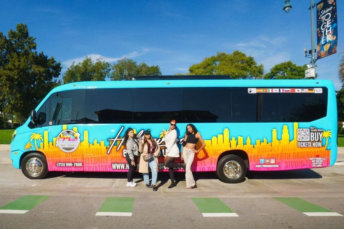
With our Hollywood Bus Tours, you can cruise the Hollywood Hills past celebrity homes, stop for photos at the Beverly Hills Sign and along Rodeo Drive, walk the Santa Monica Pier, grab lunch at the Farmers Market and The Grove, and take in skyline views from Griffith Observatory.
Every tour comes with a driver-guide who knows the city inside and out, a multilingual audio guide, and a complimentary self-guided walking tour of the Walk of Fame. For more on what to expect, see our first-time visitor tips or compare our format to hop-on hop-off bus tours.
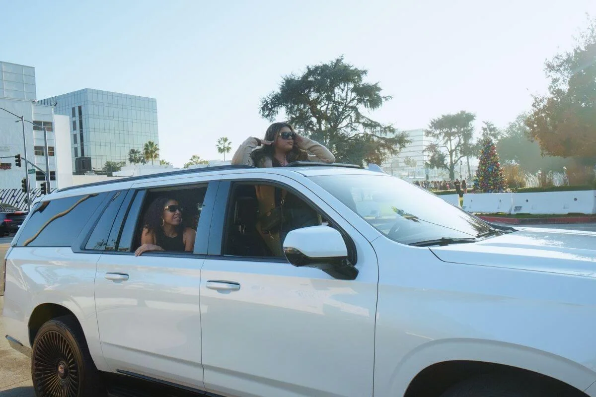
For the ultimate way to travel the city, our VIP Private SUV tours run in a Cadillac Escalade with a chauffeur-guide and hotel pickup, fully customized around your interests.
Explore all tours and book your Hollywood experience today.
Practical Tips for Getting Around LA
A few things that make the LA Metro and bus network easier to navigate:
Download the right apps
Google Maps and Apple Maps both handle LA transit well, but the Transit app gives you live tracking for buses and metro rail trains, which can save time at bus stations. The TAP LA app is also worth installing for paying fares.
Cluster your days geographically
LA is spread out, and travel times across the city add up fast. Group your sights by area. Spend one day in Hollywood and the surrounding area, another along the coast from Los Angeles to Santa Monica, and a third Downtown.
Avoid rush hour for cross-town trips
Traffic peaks from roughly 7 to 10 a.m. and 3 to 7 p.m. on weekdays. A 30-minute trip can stretch to 90 minutes during these windows, especially on freeways.
Watch for the marine layer
Morning fog regularly rolls in along the coast, especially May through July. The skies clear by midday but plan beach photos for the afternoon.
Note the renaming
Metro renamed all of its rail and bus lines using letters in 2020. The old Silver Line is now the J Line, the old Red Line is the B Line, and so on. If you are using older guides or maps, be aware of the change.
Keep your phone charged
Navigation, transit apps, and rideshare bookings drain battery quickly. A portable charger goes a long way during a full day around town.
Frequently Asked Questions About Getting Around LA
Can you visit Los Angeles without renting a car?
Yes. Most central LA neighborhoods, including Hollywood, Beverly Hills, Santa Monica, and Downtown LA, are accessible by Metro rail, bus, rideshare, and walking. A car becomes more useful only for day trips outside the city or for hotels in less-connected areas.
What is the cheapest way to get around LA?
The cheapest option for getting around is the LA Metro public transit system. Base fares are $1.75, with daily caps at $5 and weekly caps at $18 when you use a TAP card. Most short trips also work well on Metro Bike Share or LADOT DASH, which run on lower per-ride fares.
How do you get from LAX to Hollywood without a car?
Take the free LAX shuttle to the LAX/Metro Transit Center, transfer to the K Line, then transfer to the B Line at 7th St/Metro Center for Hollywood/Highland. The FlyAway bus to Union Station is also a one-seat option, with a Metro transfer to the B Line from there.
How do I pay for the Metro in LA?
Use a TAP card. You can pick one up at any Metro rail station vending machine for $2 or load a virtual TAP card onto Apple Wallet or Google Wallet through the TAP LA app. Standard contactless credit cards do not work at Metro gates.
What is the best way to see the Hollywood Sign without a car?
The Griffith Observatory offers some of the clearest public views of the Hollywood Sign, reachable by the DASH Observatory bus from the B Line. For a closer pass through the Hollywood Hills, a guided tour is a practical option.
Ready to See LA the Easy Way
Getting around Los Angeles without a car is more practical than it used to be. Between Metro rail, bus, bike share, and rideshare, you can cover most of the city without ever picking up rental keys. A TAP card and a few apps will get you most places you want to go.
For the headline sights without the planning, our Hollywood Bus Tours take you through Hollywood, Beverly Hills, and Santa Monica with driver-guides who know every street.