Route 66 covers 2,448 miles of American highway before it ends at the Santa Monica Pier, at the edge of the Pacific Ocean. That endpoint is marked by the iconic “End of the Trail” sign on the pier — one of the most photographed spots in Los Angeles.
In 2026, Route 66 turns 100, making it one of the best years to make the drive and snap that photo. Santa Monica marks the finish line, and whether you’re completing the full route or just spending a day at the pier, the history here is worth knowing before you arrive.
This guide covers the history of Route 66’s western terminus, what to see and do at the Santa Monica Pier, and everything you need to plan your visit.
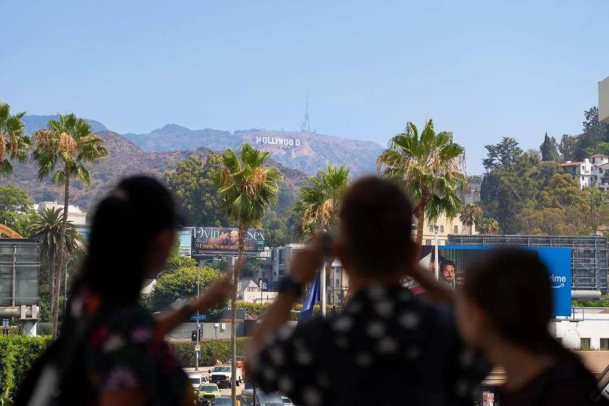
While you’re in Santa Monica, don’t miss the rest of LA’s highlights. Our highly rated tours conveniently pick you up in Santa Monica so you can cover the Hollywood Sign, Beverly Hills, Griffith Observatory, celebrity homes, and more — all in one easy ride. Book your tour here.
The Route 66 End of the Trail Sign
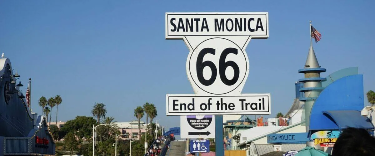
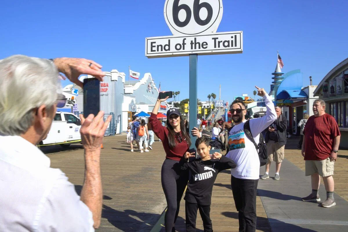
Route 66 officially ends at Lincoln and Olympic Boulevards, but the Santa Monica Pier marks the traditional end of the legendary route for nearly everyone who makes the drive. The “End of the Trail” sign at the pier is the shot every road tripper comes for — the end of 2,448 miles of American highway, with the Pacific coast as the backdrop.
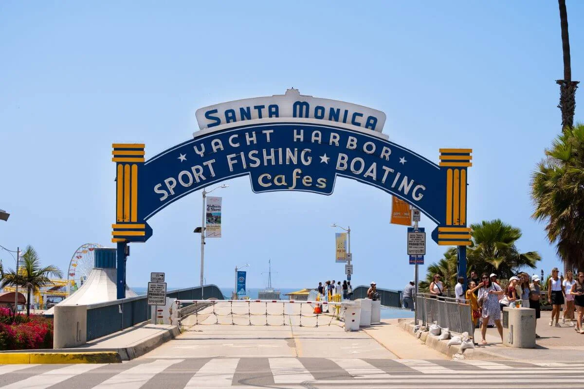
Finding the 66 sign is straightforward. Walk onto the pier from Ocean Avenue and the sign is just past the Bubba Gump Shrimp restaurant, near the Playland arcade, with Pacific Park’s Ferris wheel visible just beyond. Get there early on weekends — it draws a line.
Outside the pier, Palisades Park on Ocean Avenue features a commemorative Route 66 plaque near the City of Santa Monica’s Visitor Information Kiosk. Stop in for a Certificate of Completion — a keepsake confirming you made it to the western terminus of Route 66.
How Route 66 Became the Mother Road
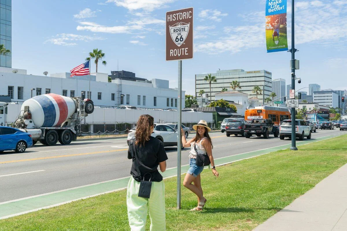
The U.S. highway system established Route 66 in 1926, connecting Chicago to Santa Monica across eight states and 2,448 miles of American road. Originally ending in downtown Los Angeles at 7th and Broadway, the route was later extended along Santa Monica Boulevard to the Pacific coast, making Santa Monica its permanent western terminus.
The Mother Road earned the nickname the Rogers Highway after Will Rogers, the Oklahoma-born entertainer who championed it. During the Dust Bowl era, it became the primary corridor west, carrying families, freight, cars and motorcycles from the midwest toward the promise of California. Roadside attractions, motor lodges, and diners lined the highway for decades, many of which still stand today.
The Cultural Legacy of Route 66
Route 66’s cultural legacy runs as deep as its asphalt. John Steinbeck immortalized it in The Grapes of Wrath, calling it “the Mother Road” — the name that stuck. Nat King Cole put it on the radio in 1946 with “(Get Your Kicks on) Route 66,” and a decade later it had its own television series. The highway became shorthand for freedom, reinvention, and the open road in a way no interstate ever could. That’s the reason people still drive it today, and why 2026 feels like such a significant moment.
Route 66 was officially decommissioned in 1985, replaced by the interstate highway system. But the legendary highway never really disappeared. Preservation groups have spent decades restoring route 66 signs, maintaining surviving stretches of boulevard, and keeping the road’s history alive. In 2026, it turns 100 — and the centennial is shaping up to be the biggest celebration the Mother Road has ever seen and one of LA’s top 2026 events.
Driving The Final Stretch — Route 66 into Santa Monica
For road trippers driving the full route, the final leg into Santa Monica is one of the most anticipated stretches of the entire journey. From Pasadena, Historic Route 66 follows Colorado Boulevard west before connecting to Santa Monica Boulevard — one of LA’s most famous streets — and carrying drivers straight through the heart of the city toward the coast.
Santa Monica Boulevard runs through West Hollywood and into Santa Monica, passing through neighborhoods that feel a world away from the desert highways and small towns that define so much of the route. By the time you cross into Santa Monica proper, the ocean is close enough to smell.
The official terminus sits at Lincoln and Olympic Boulevards, marked by a plaque at the corner. From there, most drivers follow Ocean Avenue down to the pier — the symbolic finish line that every Route 66 road tripper pictures when they imagine the end of the drive. Park on Ocean Avenue or in the Civic Center structures nearby, walk onto the pier, and find the “End of the Trail” sign.
If you’re driving in from downtown LA, the route along Santa Monica Boulevard is worth taking even if it adds time. It’s the historically accurate final leg, and arriving at the pier that way makes the ending feel earned.
Route 66 Centennial Events in Santa Monica
In 2026, Route 66 turns 100, and the Santa Monica Pier is one of the best places to mark the occasion. If you’re planning a visit around the centennial, here’s what you need to know:
The Great Route 66 Centennial Convergence
Date: April 30, 2026 Location: Santa Monica Pier Cost: Free
The Convergence is a free public gathering at the pier centered around the arrival of Wasteland Firebird — a YouTube personality driving the full Route 66 from April 10 — who is set to reach the Santa Monica Pier at 5pm. The public is welcome to show up for the arrival and celebrate the centennial at the finish line.
Route 66 Song Contest
Date: Submissions open through April 30, 2026 Location: Online, winner announced June 2026 Cost: Free to enter
Santa Monica Travel and Tourism launched the Route 66 Song Contest as part of the centennial, inviting musicians from the U.S. and internationally to submit an original song capturing Santa Monica’s connection to the Mother Road. The grand prize is $10,000.
More Events in Santa Monica
- Mel’s Diner on Lincoln Boulevard — Hosting live performances from California musicians on April 30 as part of the centennial celebrations at the official Route 66 terminus.
- Route 66 Immersive Dome Experience — Los Angeles will house one of three immersive dome experiences along the route, featuring a special Route 66 film by Vortex Immersion. Location and ticketing details still to come.
Trip Planning Tips: What To Know Before You Go
Whether you’re visiting for the centennial or just want to see the historic terminus, a little planning goes a long way.
Getting There
- The Metro Expo Line to the Downtown Santa Monica station drops you a short walk from the pier on Colorado Avenue — the easiest option on busy days.
- If you’re driving, arrive early. Public parking is available along Ocean Avenue and in the Santa Monica Civic Center structures, but spots fill fast on busy days.
The Santa Monica Pier
- The “End of the Trail” sign is just past the Bubba Gump Shrimp restaurant, near the Playland arcade. Get there early before the crowds build.
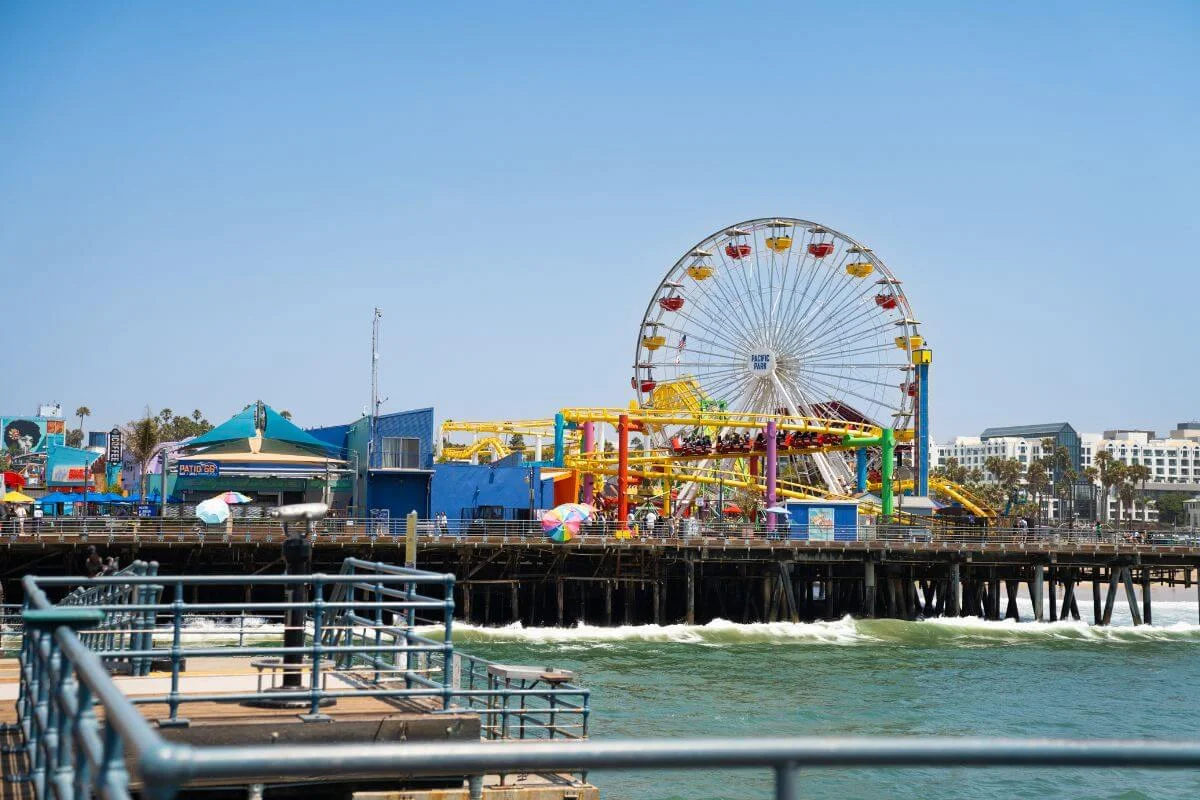
- Pacific Park’s Ferris wheel and the ocean views make for a natural extension of the visit once you have your photo.
Don’t Skip Palisades Park
Just off Ocean Avenue, Palisades Park features a commemorative Route 66 plaque near the City of Santa Monica Visitor Information Kiosk. Stop in and pick up a Certificate of Completion — the official keepsake confirming you made it to the western terminus of Route 66.
Already planning your trip? Hollywood Bus Tours departs directly from Santa Monica — book your spot and cover all of LA’s top highlights in one easy ride.
Attractions Near the Santa Monica Historic Route 66 End Sign
Santa Monica has enough to fill a full day around the centennial events. Here are the highlights worth knowing before you arrive.
- Santa Monica Pier — Beyond the Route 66 marker, the pier has Pacific Park’s Ferris wheel, arcade games, and unobstructed ocean views. Give yourself at least 45 minutes here.
- Third Street Promenade — A pedestrian-only shopping and dining strip three blocks from the pier.
- Palisades Park — A long, narrow bluff-top park running along Ocean Avenue with sweeping views of the Pacific. The Route 66 commemorative plaque and Visitor Information Kiosk are located here.
- Venice Beach — A short drive or bike ride south of the pier, Venice Beach boardwalk is one of the most distinct stretches of coastline in LA. Worth an hour if you have the time.
- Montana Avenue — One of Santa Monica’s best local shopping and dining streets, away from the tourist crowds. Good for a quieter breakfast or coffee before the day kicks off.
- Want more ideas? Check out our guide to the best day trips from Santa Monica!
Frequently Asked Questions
Where does Route 66 end?
Route 66 officially ends at the intersection of Lincoln and Olympic Boulevards in Santa Monica, California. The symbolic finish line for most road trippers is the Santa Monica Pier, where the honorary “End of the Trail” sign marks the western terminus of the Mother Road. The pier sits at the edge of the Pacific Ocean, making it one of the most photographed endpoints of any road in the world.
How much of Route 66 is still drivable?
A significant portion of Route 66 is still drivable today. Estimates put the drivable stretches at roughly 85% of the original route across all eight states, though some sections have been bypassed by interstates or are in poor condition. Oklahoma has the longest continuous drivable stretch at over 400 miles. The final California leg into Santa Monica along Santa Monica Boulevard is fully drivable and historically accurate.
Can you visit both the official terminus and the Santa Monica Pier in one trip?
Yes, and most visitors do both. The official terminus plaque at Lincoln and Olympic Boulevards is a quick stop — park nearby, get the photo, and move on. From there the pier is less than a mile away. Plan 45 minutes to an hour at the pier to find the End of the Trail sign, walk the boardwalk, and take in Pacific Park before moving on to the rest of Santa Monica.
Where can you park to see the Route 66 End of the Trail sign?
The closest parking to the Santa Monica Pier is along Ocean Avenue and in the Santa Monica Civic Center parking structures nearby. Spots fill fast on busy days. The Metro Expo Line to the Downtown Santa Monica station is the most stress-free option if you’re coming from elsewhere in LA.
Where should I stay near the Santa Monica Pier?
The Shore Hotel at 1515 Ocean Ave sits directly across from the pier and is the closest full-service hotel to the Route 66 terminus. It also happens to be the departure point for Hollywood Bus Tours, making it a convenient base for exploring both Santa Monica and the rest of LA.
See All of LA’s Top Highlights from Your Santa Monica Base
Santa Monica is where Route 66 ends and the perfect starting place for your LA adventure. Hollywood Bus Tours picks you up directly from the Shore Hotel at 1515 Ocean Ave — steps from the pier — in comfortable vehicles with local guides who know the city inside and out.
See the Hollywood Sign, Beverly Hills, Rodeo Drive, celebrity homes, and more on our Hollywood, Beverly Hills, & Celebrity Homes Open Air Tour, departing directly from Santa Monica.
For the complete Hollywood experience, check out our Half Day Best of LA Tour where we take you to the Hollywood Walk of Fame, Griffith Observatory, the Farmers Market and The Grove, and more — all conveniently from your Santa Monica base.
Book your tour today and see why we’re LA’s most trusted sightseeing company, backed by 18,000+ five-star reviews.